A contractor broke ground on a medical office expansion near Fort Sanders and hit weathered dolomite six feet down where the boring log showed residual clay. That kind of surprise costs weeks and tens of thousands in change orders. Seismic tomography catches those transitions before the backhoe does. Knoxville sits on the Tennessee River, with the Knox Group dolomites and Chickamauga limestone creating a subsurface that shifts from competent rock to deep saprolite within a single lot. Refraction surveys map the top of rock and identify fracture zones; reflection profiles resolve layering where velocity inversions hide weak seams. For projects that need both depth and lateral detail, we combine the tomography data with CPT soundings to calibrate the velocity model against measured tip resistance and pore pressure in the overburden.
In Knoxville's karst, a 50-foot geophone spread can reveal a dissolution trough that a boring grid would walk right past.
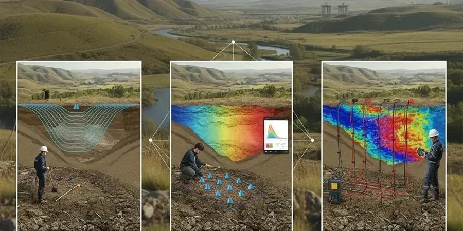
Process overview
Knoxville averages just over 47 inches of rain a year, and that water moves fast through the epikarst. The result is a weathering profile that can drop competent rock 40 or 50 feet below a stiff clay cap, something standard borings miss between stations. Our refraction surveys use hammer, weight-drop, or accelerated weight-drop sources with 24- to 48-channel geophone spreads, generating a P-wave velocity model that resolves the soil-rock interface and flags voids or mud-filled seams as low-velocity anomalies. Reflection processing adds SH-wave data where the water table or clay layers create acoustic impedance contrasts. Deliverables include tomographic cross-sections, interpreted bedrock surface maps, and rippability charts tied to Caterpillar D8-D11 performance curves. Site classification follows the Vs30 framework in ASCE 7-22 Chapter 20, so the structural engineer gets a defensible Site Class without extrapolating from blow counts alone.
Local context
Downtown Knoxville near the river sits on alluvium and fill over limestone ledges, while West Knoxville developments in the Bearden area encounter thick residual clays over pinnacled rock. The risk profile is different in each. Downtown, a reflection survey can miss a steep-walled cut in the bedrock under 15 feet of gravel; by the time a caisson hits it, the rig is already fighting a boulder or a void. West Knoxville sites can have a stiff red clay that looks like refusal to a penetrometer but masks a deep weathering trough, setting up differential settlement under mat foundations. Seismic tomography reduces those blind spots. We shoot overlapping lines so velocity inversions and lateral pinch-outs show up in the cross-sections, and we flag any zone where the rock surface drops more than 10 feet over a 25-foot horizontal run for follow-up investigation.
Common questions
What does seismic tomography cost for a typical Knoxville commercial lot?
For a half-acre to one-acre commercial site in the Knoxville area, seismic tomography typically ranges from US$2,580 to US$5,460 depending on the number of lines, source type, and whether we run both refraction and reflection. A single 230-foot refraction line with a sledgehammer source is at the lower end; adding SH-wave reflection or an accelerated weight drop for deeper penetration moves toward the upper end. We provide a fixed-price proposal after reviewing the site geometry and the geotechnical questions the engineer needs answered.
How deep can seismic refraction see in Knoxville's geology?
With a sledgehammer and a 230-foot spread, we typically image 30 to 50 feet in the residual soils and weathered rock common around Knoxville. Switching to an accelerated weight drop or using longer spreads pushes the depth of investigation past 80 feet, enough to reach competent limestone or dolomite on most lots. The actual depth depends on the velocity contrast and the geometry of the rock surface, not just the energy input.
Does seismic tomography replace borings for an IBC site classification?
No, it complements them. Seismic tomography gives you a continuous velocity cross-section that fills the gaps between borings, which is critical in Knoxville's karst where rock conditions change abruptly. The Vs30 value from a ReMi or downhole survey feeds directly into ASCE 7-22 site classification, but borings are still needed for soil sampling, SPT N-values, and laboratory testing to confirm the lithology behind the velocity model.